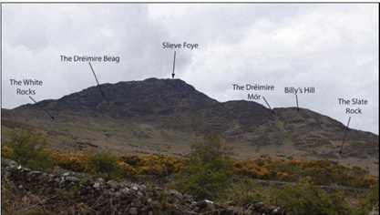
This photo of the south face of Slieve Foye immediately above Carlingford is from “Mapping the Minor Placenames of Co Louth” by archaeologist Eve Campbell and Ardaghy man Andrew McGuinness.
The ‘Dreimire Beag’ gully to the left of the photo is better known to hillwalkers as the Devil’s Ladder, providing an extremely tough shortcut to the summit. Dreimire Mor, on the other hand, is a great way to get lost since it doesn’t really go anywhere.
Did you ever climb up to the Goalyin? Can you find the Bainseach, the Ball Alley, Bog Bane, The Brockey, Corncrin, Cronambroc or Dane’s Table?
They are all in the Liberties, along with Owney’s River, Pat’s Rock, Polnashanna and the White Face. These names will all be lost in a generation unless we do something about it. Eve and Andrew did not attempt interpretation or a proper Gaelic rendering of the placenames because that was beyond their scope, but there are plenty of scholars who could do that for us if we could organise a proper placenames workshop. The study has hundreds of entries with the richest sources in the former Gaeltacht of Omeath, but there are numerous names from every townland in Cooley.
The report is available to download at https://www.academia.edu/…/Mapping_the_Minor_Place

