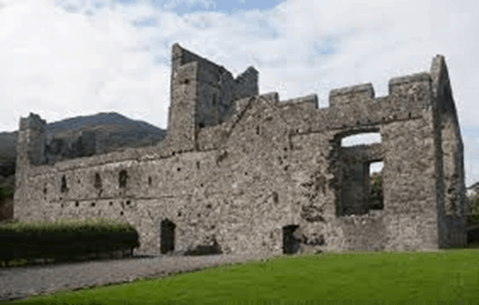
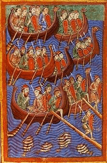
In 1305 Richard Óg de Burgh, known as the Red Earl of Ulster, invited the Dominican Order to establish a priory in Carlingford to be dedicated to St Malachy. They got off to a poor start, soon becoming victims of the rampaging Scottish army led by Edward Bruce, younger brother of the Scottish king Robert. Edward crowned himself king of Ireland in Dundalk in 1316, but he lost the kingship of Ireland along with his head at Faughart two years later.
The priory was just within the recently extended town walls, but there was more trouble ahead. The population of Carlingford fell so sharply in the Black Death at the end of the 1340s that there was not enough money to maintain the wall or manpower to guard it. The town literally shrank, back to a new wall close to the Heritage Centre, and the Dominicans were once more out in the cold. By 1423 they had their own fortifications and battlements, including a machiolation supported on two stone corbels above the main door. This would have been handy for pouring boiling oil and the contents of priory toilets down onto attackers.
The priory was closed down in the 1540s when Henry VIII dissolved all the monasteries and put up for sale as ‘a strong mansion house in no need of expenditure on repairs’. It was again the scene of battle in the long wars of the 1640s and 1650s, according to local folklore it was used by the Cromwellian cavalry for stabling. Things got easier for the practice of Catholicism with the Restoration under Charles II in 1660, the Dominicans tried to return, but the Franciscans had got in first to occupy the building.
By 1689 it was back at war again, occupied by a Jacobite army under the Duke of Berwick which was retreating as William of Orange advanced from the north. Persecution returned in the 1700s, the Franciscans were on the run and the priory was used as a depot by herring fishermen. It is thought a large amount of the stone was taken by William Stannus for the construction of Ghan House in 1726.